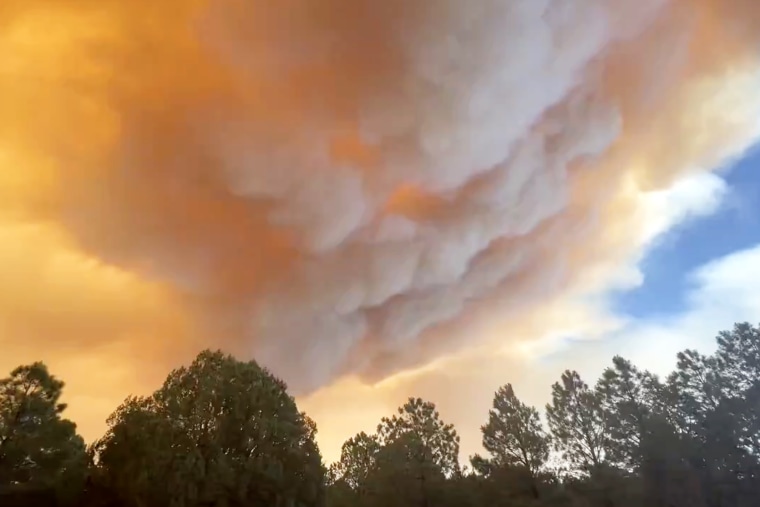
Residents in the New Mexico village of Ruidoso were told to immediately flee Monday because of a wildfire that was discovered west of town that morning and grew to more than 5,000 acres by the end of the day, officials said.
“Immediate mandatory 'go' evacuation for the Village of Ruidoso — go now!!” the village government said on its Facebook page in all capital letters shortly before 7 p.m.
The South Fork Fire was discovered at around 9 a.m. Monday on the Mescalero Reservation west of the village of more than 7,000, and by 11:30 p.m. it had grown to an estimated 5,252 acres, the New Mexico Forestry Division said.
"Fire growth has been rapid with extreme fire behavior," the division said.
As of Tuesday afternoon, the South Fork Fire spanned 13,921 acres and was still 0% contained.
An estimated 500 structures were impacted in the fire. The Red Cross reported 270 individuals checked in to shelters in Roswell and 120 in Capitan, according to an update by the New Mexico State Forestry Division shared on the village government's Facebook page.
“Crews worked together last night to stop the fire’s spread and providing structure protection where they could. Currently fire behavior is creeping, but a concern today is increased winds that could push the fire further to the east and the northeast,” the update said.
The cause of the South Fork Fire is under investigation, and the village remains under mandatory evacuation Tuesday afternoon.
Firefighters were tackling the flames by air in tandem with ground resources.
Another fire, the Salt Fire, is also burning across 4,876 acres in the Mescalero Reservation, Otero County, and southwest of Ruidoso, and is 0% contained. Fire officials said this fire’s progression “slowed somewhat during the night” but the blaze is still “creeping through difficult, mountainous terrain south of Ruidoso.”
Weather conditions are similar Tuesday to Monday with 15 to 20 mph winds forecast.
Multiple evacuation orders have been issued, with residents of the town told to leave immediately and warned against trying to pack valuables or to defend their property. Highways 48 and 70 leading to the town were shut.
No deaths appear to have been reported as of Tuesday afternoon.
Mary Lou Minic knew there was a fire in the area, but not how serious the danger was. She was among those now safe at an at an evacuation center in Roswell Monday night.
“We were getting ready to sit down to a meal and the alert came on: Evacuate now, don’t take anything or plan to pack anything, just evacuate,” Minic told NBC affiliate KOB of Albuquerque. “And within three to five minutes, we were in the car, leaving.”
Hot ash from the fire was falling in Alto, a community north of Ruidoso, Ruidoso's government said. Part of U.S. Highway 70 near the reservation was closed, it said.
The reservation said on its website that the Mescalero conservation was going door to door to tell people in affected areas to leave immediately and that fire and vehicle restrictions and closures were in effect.
The Mescalero Apache Tribe said it was opening an evacuation center at Inn of the Mountain Gods Convention Center, and it said all nonessential tribal employees were being encouraged to volunteer Tuesday. It also offered to house livestock at a rodeo center.
Electricity provider PNM de-energized part of Ruidoso at the request of first responders, the town said.
An evacuation center was open at the gym of Eastern New Mexico University-Roswell in Roswell, around 70 miles east of Ruidoso, and the nearby city of Alamogordo said it would send firefighters to help.
A webcam view in Midtown Ruidoso showed the sky behind the town glowing red on Monday evening. By Tuesday morning, the glow was no longer visible but thick smoke had enveloped the town.

Ruidoso, Alto and the reservation are in the Sierra Blanca mountain range, around 130 miles southeast of Albuquerque.
The blaze broke out as much of the American Southwest, including parts of New Mexico, were under "red flag" warnings because of the risk of fires due to very dry air and winds.
In Calaveras County, California, east of Stockton, a wildfire that has burned around 1,900 acres also forced emergency evacuations Monday.
Around 5,000 people were without power because of the fire. Aerial video showed planes dumping pink fire retardant ahead of the blaze and a wall of thick smoke.
The so-called Aero Fire started near Aero Road and Hunt Road in Copperopolis at around 3:20 p.m., according to the California Department of Forestry and Fire Protection, known as Cal Fire.
CORRECTION (June 17, 2024, 10:56 p.m. ET): An earlier version of this article misidentified the fire burning in the Mescalero Reservation. It is the South Fork Fire, not the Salt Fork Fire.

