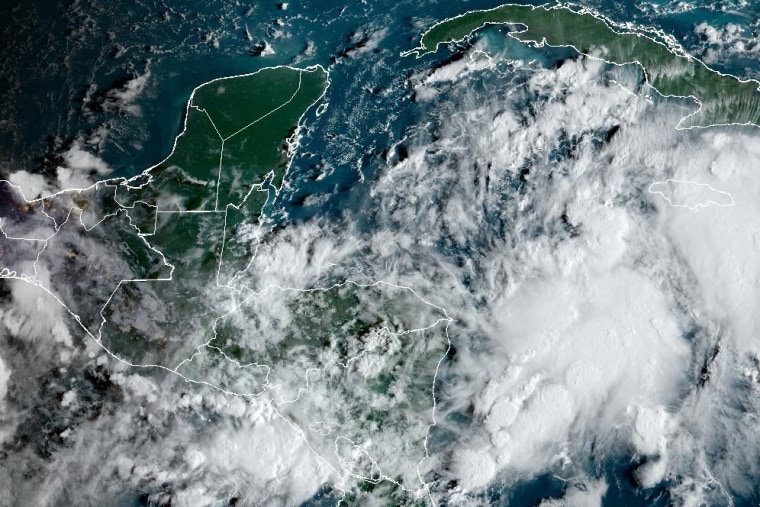
A disturbance in the Caribbean Sea is expected to strengthen into a hurricane that will take aim at Florida midweek.
The system, which for now is known as Potential Tropical Cyclone 9 but would become Helene if it's upgraded to a storm, on Monday afternoon was about 100 miles southwest of Grand Cayman with maximum sustained winds of 35 mph and higher gusts, according to the National Hurricane Center. It was moving north-northwest at 7 mph.
A turn toward the northwest is expected Tuesday, followed by an acceleration toward the Northeast on Wednesday and Thursday, the hurricane center said.

"On the forecast track, the center of the system is forecast to move across the northwestern Caribbean Sea through Tuesday night, and then over the eastern Gulf of Mexico on Wednesday and Thursday,” the hurricane center said in an update Monday evening.
The disturbance is forecast to become a hurricane Wednesday and continue to strengthen as it moves through the eastern Gulf of Mexico. A tropical storm is defined as having winds of 39 mph or higher and a hurricane of 74 mph or higher, according to the National Weather Service.
As it enters the Gulf of Mexico, the system could strengthen due to a staple fuel for hurricanes: warm water. While average sea surface temperatures in the Gulf of Mexico peak near 80 degrees in summer, many National Oceanic and Atmospheric Administration-monitored buoys on a fall Monday measured temperatures from 84 to 89 degrees.
Florida Gov. Ron DeSantis declared a state of emergency in 41 counties Monday ahead of the potential storm's "significant threat" of heavy rainfall, flooding, storm surge and damaging winds to the state's Gulf coast.
The potential storm may bring 4 to 12 inches of rain to western Cuba and the Cayman Islands and 2 to 6 inches to the eastern Yucatán Peninsula, carrying a risk of flash and urban flooding, the hurricane center said.
"Heavy rainfall will spread into the Southeast U.S. starting on Wednesday and continuing through Friday, bringing a risk of flash and river flooding," the center said.
Around 2 to 4 feet of storm surge is expected along the southern coast of Pinar del Río in western Cuba and the east coast of the Yucatán Peninsula. In Florida, 1 to 3 feet of storm surge could affect the Dry Tortugas and the Keys.
Sandbags were being distributed to residents in Tallahassee and Gulfport ahead of potential flooding.
A hurricane watch has been issued for Cabo Catoche to Tulum, Mexico, and for Pinar del Río, Cuba. A tropical storm warning is in effect in Rio Lagartos in Tulum and Cuba's Artemisa, Pinar del Río and Isla de la Juventud, or the Isle of Youth.
The Dry Tortugas and the Lower Keys are under a tropical storm watch.
A hurricane watch, often issued as a warning with 48 hours' notice of incoming conditions, means hurricane-force winds, torrential rain and inundated waterways are possible, the National Weather Service says.
A tropical storm watch, also ideally issued with 48 hours' notice of incoming activity, warns of possible tropical storm-force winds, rain and inundated waterways, it says.
