A white Christmas arrived after all for parts of the Western U.S.
Snow pounded mountains across California late Saturday after it gave the Seattle area a rare show Saturday afternoon.
There were multiple reports of snow falling around Seattle, and the National Weather Service said "snowy, difficult travel" should be expected on local roads.
A "seemingly endless" pattern of low pressure fronts from the Pacific were striking the West Coast, with cold storms expected through midweek, federal forecasters said.
Snow was also reported in the Portland, Oregon, area, where "cold arctic air" was moving in, forecasters said. Recent forecasts showed that at least an inch of snow was likely to fall Sunday in the Seattle and Portland regions, which typically don't get snow.
Eugene, Oregon, declared a snow and ice emergency Sunday morning, urging residents to move their vehicles from emergency routes.
"The weather is expected to continue to deteriorate throughout the day on Sunday as more snow showers move through the area," the city warned. "Freezing temperatures Sunday evening will likely also further deteriorate conditions."
A potential squall was also on the horizon Sunday afternoon for the Boulder, Colorado, area, the National Weather Service said.
There was "heavy, intense snowfall" Saturday in the Tahoe Basin and in Reno, Nevada, the local weather service office said. For the second day in a row, Interstate 80 was closed near Donner Summit, the California Highway Patrol said. Low visibility was blamed.
Bands of rain and thunderstorms moved through the San Francisco Bay Area on Saturday. A flood advisory for San Francisco was canceled in the late afternoon.
Snow covered about a fourth of the country Saturday, and it eventually made a promised return to the foothills of California, where plummeting temperatures and a new band of moisture produced palm tree-adjacent snow by late night.
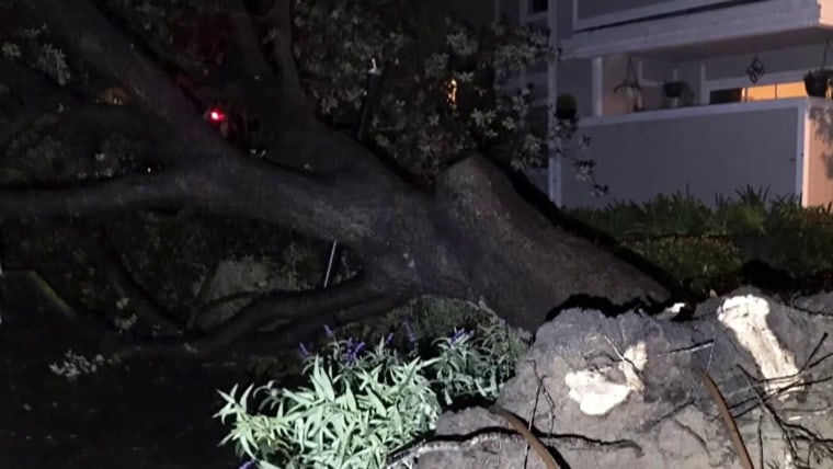
A 70-mile stretch of interstate over the top of the Sierra Nevada was closed Saturday when a storm that dropped nearly 2 feet of snow on some ski resorts around Lake Tahoe overnight got a second wind.
A glimpse of powder was possible even in San Diego, where snow is rare, but it might come too late to count as a white Christmas.
"We could get a light dusting in San Diego County mountains" overnight, weather service meteorologist Casey Oswant said.
The University of California, Berkeley's Central Sierra Snow Lab said Sunday that more than 70 inches of snow fell in the last week, 29 inches of it occurring over the past day.
The lab said it was 2 feet of snow short of surpassing the state's snowiest December on record, which was in 1970, after 179 inches fell.
Other areas of California, however, had a wet and rainy Christmas as storms continued to drench the state, causing flash flooding and evacuations in some areas over the holiday period.
Meanwhile, temperatures continued to soar in parts of the Southern Plains. Federal forecasters blamed an "anomalously warm low-level thermal ridge."
"Record-breaking high temperatures are likely from the Southern Plains to the Mid-Atlantic" on Sunday, the National Weather Service said.
"Much of the South remains remarkably warm as highs soar into the 80s once again in Texas and Oklahoma," it said. "The warmest average temperatures for Sunday will stretch from northern Texas into southern Kansas where temperatures will be 25-35 degrees above average."
