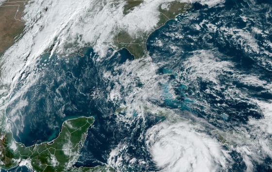
Hurricane Rafael made landfall in western Cuba Wednesday afternoon after it became a Category 3 hurricane earlier in the day.
Rafael made landfall around 4:15 p.m. in the Cuban province of Artemisa, just east of Playa Majana, the National Hurricane Center said.
By 10 p.m. Wednesday, the storm's eye was moving away from western Cuba, the hurricane center said. Storm surge, wind and rain should subside on the island Wednesday night as Rafael traverses the Gulf of Mexico.
After landfall, the storm weakened to a Category 2 with maximum sustained winds of 105 mph and was moving northwest at 13 mph.
Rafael knocked out Cuba's power grid, with state TV reporting the entire population of 10 million people was without electricity. This is the second time the island's power grid has collapsed in less than a month.
Rafael strengthened into a Category 2 and then Category 3 hurricane Wednesday. A Category 3 storm, which is classified as a major hurricane, has winds of 111 to 129 mph, under the Saffir-Simpson Hurricane Wind Scale.
Rafael is expected to move across the southern Gulf over the next few days.
A hurricane warning is for the Cuban provinces Pinar del Rio, Artemisa, La Habana and Mayabeque. A tropical storm warning is in effect for the lower and middle Florida Keys from Key West to west of the Channel 5 Bridge, and the Dry Tortugas.
An additional 2 to 4 inches of rainfall are expected into Thursday morning across parts of western Cuba, amounting to 12 inches of total accumulations from the storm.
"This may lead to areas of flash flooding and mudslides, especially along the higher terrain," the hurricane center said.
In the U.S., tropical storm conditions are expected in the lower and middle Florida Keys on Wednesday into the evening.
Rainfall totals of 1 to 3 inches are expected for the lower and middle Florida Keys. The hurricane center said, "a couple of brief tornadoes" are still possible in parts of the lower Florida Keys Wednesday night.

